


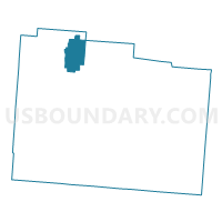
PRECINCT BATH TWP 277, Greene County, Ohio
About
Outline

Summary
| Unique Area Identifier | 646840 |
| Name | PRECINCT BATH TWP 277 |
| County | Greene County |
| State | Ohio |
| Area (square miles) | 8.64 |
| Land Area (square miles) | 8.63 |
| Water Area (square miles) | 0.01 |
| % of Land Area | 99.85 |
| % of Water Area | 0.15 |
| Latitude of the Internal Point | 39.80007650 |
| Longtitude of the Internal Point | -83.96008160 |
Maps

Graphs
Select a template below for downloading or customizing gragh for PRECINCT BATH TWP 277, Greene County, Ohio


Neighbors
Neighoring Voting District (by Name) Neighboring Voting District on the Map
- Voting District MR 5, Clark County, OH
- PRECINCT BATH TWP 276, Greene County, OH
- PRECINCT BEAVERCREEK 092, Greene County, OH
- PRECINCT FAIRBORN 204, Greene County, OH
- PRECINCT FAIRBORN 206, Greene County, OH
- PRECINCT FAIRBORN 226, Greene County, OH
- PRECINCT MIAMI TWP 456, Greene County, OH
- PRECINCT XENIA TWP 351, Greene County, OH
Top 10 Neighboring County Subdivision (by Population) Neighboring County Subdivision on the Map
- Beavercreek township, Greene County, OH (52,156)
- Bath township, Greene County, OH (39,392)
- Mad River township, Clark County, OH (11,156)
- Xenia township, Greene County, OH (6,537)
- Miami township, Greene County, OH (4,790)
Top 10 Neighboring Place (by Population) Neighboring Place on the Map
Top 10 Neighboring Unified School District (by Population) Neighboring Unified School District on the Map
- Beavercreek City School District, OH (53,697)
- Fairborn City School District, OH (41,848)
- Xenia Community City School District, OH (36,823)
- Greenon Local School District, OH (12,254)
- Yellow Springs Exempted Village School District, OH (4,177)
Top 10 Neighboring State Legislative District Lower Chamber (by Population) Neighboring State Legislative District Lower Chamber on the Map
- State House District 70, OH (123,974)
- State House District 84, OH (116,799)
- State House District 72, OH (102,568)
Top 10 Neighboring State Legislative District Upper Chamber (by Population) Neighboring State Legislative District Upper Chamber on the Map
Top 10 Neighboring 111th Congressional District (by Population) Neighboring 111th Congressional District on the Map
Top 10 Neighboring Census Tract (by Population) Neighboring Census Tract on the Map
- Census Tract 2106.03, Greene County, OH (5,904)
- Census Tract 2009, Greene County, OH (5,655)
- Census Tract 2406, Greene County, OH (5,528)
- Census Tract 30.01, Clark County, OH (3,145)
- Census Tract 2802, Greene County, OH (1,426)